News
Hurricane Laura makes landfall; Warren county under wind advisory Thursday

* WHAT…Southeast winds 20 to 30 mph with gusts up to 40 mph expected.
* WHERE…Portions of central, north central, northwest, southwest and west central Mississippi.
* WHEN…Until 7 p.m. CDT this evening.
* IMPACTS…Gusty winds could blow around unsecured objects. Tree limbs could be blown down and a few power outages may result.
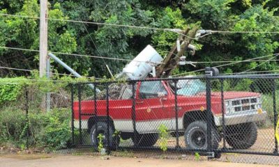
* ADDITIONAL DETAILS…As Hurricane Laura makes landfall and moves inland, winds will extend far out from the center.
PRECAUTIONARY/PREPAREDNESS ACTIONS…
Use extra caution when driving, especially if operating a high profile vehicle. Secure outdoor objects.
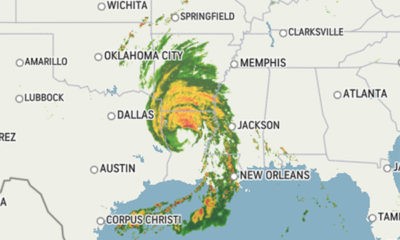
Laura has made landfall along the southwest Louisiana coast. The center of Laura is forecast to move over northwestern Louisiana today, across Arkansas tonight, and over the mid-Mississippi Valley on Friday. Laura made landfall as a major hurricane and is forecast to weaken as it moves farther inland. This will bring tropical storm force winds into our Louisiana parishes and extreme southeast Arkansas counties this morning. Tornadoes and damaging wind gusts will be possible over portions of northeast Louisiana, extreme southeast Arkansas and western Mississippi through today. Inland flooding will also be possible over portions of northeast Louisiana and extreme southeast Arkansas through today.
POTENTIAL IMPACTS
* WIND:
Protect against dangerous wind having possible significant impacts across northeast Louisiana and southeast Arkansas.
Potential impacts in this area include:
– Some damage to roofing and siding materials, along with damage to porches, awnings, carports, and sheds. A few buildings experiencing window, door, and garage door failures. Mobile homes damaged, especially if unanchored. Unsecured lightweight objects become dangerous projectiles.
– Several large trees snapped or uprooted, but with greater numbers in places where trees are shallow rooted. Several fences and roadway signs blown over. –
Some roads impassable from large debris, and more within urban or heavily wooded places. A few bridges, causeways, and access routes impassable.
– Scattered power and communications outages, but more prevalent in areas with above ground lines. Also, protect against hazardous wind having possible limited impacts across western Mississippi. Elsewhere across Central Mississippi, Northeast Louisiana, and extreme Southeast Arkansas, little to no impact is anticipated.
* TORNADOES:
Protect against a tornado event having possible limited impacts across Central Mississippi, Northeast Louisiana, and extreme Southeast Arkansas.
Potential impacts include:
– The occurrence of isolated tornadoes can hinder the execution of emergency plans during tropical events.
– A few places may experience tornado damage, along with power and communications disruptions.
– Locations could realize roofs peeled off buildings, chimneys toppled, mobile homes pushed off foundations or overturned, large tree tops and branches snapped off, shallow-rooted trees knocked over, moving vehicles blown off roads, and small boats pulled from moorings.
* FLOODING RAIN:
Protect against heavy rainfall flooding having possible extensive impacts across northeast Louisana and extreme southeast Arkansas.
Potential impacts include:
– Rainfall flooding may prompt many evacuations and rescues.
– Localized flash flooding at underpasses, low-lying spots, and poor drainage areas. Some streets and parking lots take on moving water as storm drains and retention ponds overflow. Driving conditions may become hazardous.
* OTHER PREPAREDNESS INFORMATION:
If heading to a community shelter, become familiar with the shelter rules before arrival, especially if you have special needs or have pets.
Take essential items with you from your Emergency Supplies Kit.
Keep cell phones well charged. Cell phone chargers for automobiles can be helpful, but be aware of your risk for deadly carbon monoxide poisoning if your car is left idling in a garage or other poorly ventilated area.
Rapidly rising flood waters are deadly. If you are in a flood-prone area, consider moving to higher ground. Never drive through a flooded roadway. Remember, turn around don’t drown!
If a Tornado Warning is issued for your area, be ready to shelter quickly, preferably away from windows and in an interior room not prone to flooding.
If driving, scan the roadside for quick shelter options.
If in a place that is vulnerable to high wind, such as near large trees, a manufactured home, upper floors of a high-rise building, or on a boat, consider moving to a safer shelter before the onset of strong winds or flooding.
Closely monitor weather.gov, NOAA Weather radio or local news outlets for official storm information. Be ready to adapt to possible changes to the forecast. Ensure you have multiple ways to receive weather warnings.
* ADDITIONAL SOURCES OF INFORMATION:
– For information on appropriate preparations see ready.gov
– For information on creating an emergency plan see getagameplan.org
– For additional disaster preparedness information see redcross.org
NEXT UPDATE
The next local statement will be issued by the National Weather Service in Jackson MS around 10 a.m. CDT, or sooner if conditions warrant.
See a typo? Report it here.